January 18, 2010; Part 2: Over the next 30 years, the Portland Metro area is projected to increase in population size by 1 million people.
Portland metro area that occupies the 3 surrounding counties —Multnomah, Clackamas and Washington — have wisely managed their urban growth efficiently through the use of the Urban Growth Boundary (UGB) process.
This is part 2 of a discussion with Jim Johnson, Land Use and Water Planning Coordinator from the Oregon Department of Agriculture. Johnson explains the urban and rural reserves process that seeks to manage competing interests while preserving land for future generations.
Each city and county within the state as administered by the Oregon Department of Land Conservation and Development (LDLC), are required to develop an UGB within their jurisdiction; urbanization is only allowed to occur (expand) inside of this boundary area, over a 20 year horizon of time. What makes this process unique, is the level of coordination involved from the local to the state level, coordination between cities, counties, and the state that oversees (and must approve) the final process for each locale. Further, within the Portland Metro area, where the largest population center of the state resides, there is great pressure for urbanization. It is here, unlike anywhere else in the country—the UGB is also coordinated by a super agency, Metro, that exercises land use jurisdiction over the 3 counties and 20 cities that comprise this region.
What are Urban and Rural Reserves: (from Oregon Metro)
“Urban Reserves will be designated by Metro on lands currently outside the urban growth boundary that are suitable for accommodating urban development over the next 40 to 50 years. Rural Reserves will be designated by each county on lands outside the current urban growth boundary that are high value working farms and forests or have important natural features like rivers, wetlands, buttes and floodplains. These areas will be protected from urbanization for the next 40 to 50 years.”
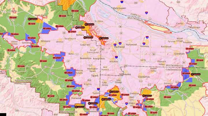
These land use designations will provide the basis for managing future urban growth, the degree to which the current UGB may expand over the next 40-50 years, and where that expansion will occur. Land use planning is often a balancing act of competing interests, needs, and desires of a community and a region. Agricultural lands are largely in competition with industrial uses, to the degree both require large tracts of open land to operate.
As Jim Johnson, land use planner for the Oregon Department of Agriculture explains in the video, the Urban Reserves designation carries risk in the form of long-term uncertainty to farmers whose land falls under this new designation. Regardless of whether their land, or areas near their land become absorbed inside an expanding UGB line, the speculative value of their property will increase with an Urban Reserves designation (as opposed to a Rural Reserves designation), and the economic pressures of approaching urbanization will likely promote the demise of farming along these urban fringe boundaries.
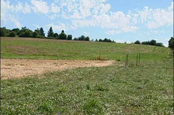
Agriculture is one of the most important economic engines of the state’s economy. The soils that occupy much of the open lands under consideration for Urban Reserves designation are also among the finest agricultural soils in the state, possibly in the world. Once these areas become open to urbanization, it becomes much harder for new farmland to be used for farming, and existing farms to thrive.
Our world is changing faster than our ability to comprehend the full impact of the changes that are underfoot. Changes to the environment from the threats of climate change, of increasing water scarcity, and of environmental degradation argue for caution in our future growth plans, and an emphasis on the efficient use of land inside an established UGB lines.
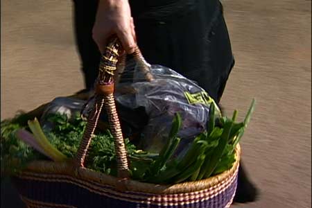
The growing importance of urban agriculture to the quality of local communities, and to its future economic well-being, are issues that will likely only increase in importance over time.
The results of this Reserves Process, and how it’s able to play out over the next several decades will determine in large measure whether the Portland area preserves its unique character of small urban farms, specialty seed and crop production zones, and farmer’s markets near its urban center. What’s at stake is the local food production and local food economy of this region; the ability to meet the local needs of an additional 1 million people for food, and help feed a world outside its borders— growing ever more hungry for quality food.
What Happens Next: (from Oregon Metro)
“The Core 4 [ editor’s note: the Core 4 are the 3 counties plus Metro] completed their initial proposed regional reserves map on Dec. 16 and have released it for public consideration. In early 2010, you will have an opportunity to attend public open houses to view maps, learn about the rationale behind the boundary lines and read the intergovernmental agreements that will formally establish the reserves system. County and Metro staff and elected officials will be on hand to answer questions and you’ll have the opportunity to provide your perspective. Or you can attend a “virtual open house” on the Metro web site where you can view the same materials and answer survey questions.”
“Following this comment period, the Core 4, on behalf of their respective governments, will propose final maps and intergovernmental agreements for formal approval by the three commissions and Metro Council in February 2010. [ Editor’s note: Final maps and agreements will be forwarded to the state’s land use agency for review before final approval.” [ Editor’s note: The Oregon Department of Land Conservation and Development will review the final maps and intergovernmental agreements to insure consistency with the state laws. ]
To find out more information about the Reserves Process, and how you can participate, visit the Oregon Metro site. Download current Reserves map (PDF).
- Social Media Message
- Custom Tweet & Card Data
- Pinterest Image
- Share Message (Advanced)
- GA Campaign Tracking Options
Social Media Message
Optimize your social share message on all social networksSocial
Sharing Optimization is important for each site. Without using it you
have no control over shared information on social networks. We highly
recommend to activate it (Facebook sharing tags are used on almost all
social networks so they are the minimal required).How to customize shared informationI see wrong share informationTest & Fix Facebook Showing Wrong InformationFacebook Preview
Recommended image size used for sharing is 1,200 x 628 pixels or image with an aspect ratio of 1.91:1
Urban Growth Boundaries: The Reserves Process (Video)
Three Portland, Oregon counties must make decisions about the urban growth boundaries and future land development.
Analysis: Good Title length is OK Description length is OK Your image is big enough but it is not in the recommended apsect ratio of 1,91:1
Social Media Title
Add
a title that will populate the open graph meta tag which will be used
when users share your content onto most social networks. If nothing is
provided here, we will use the post title as a backup. We recommend
usage of titles that does not exceed 60 characters
60 characters remainSocial Media Description
Add
a description that will populate the open graph meta tag which will be
used when users share your content onto most social networks.We recommend usage of description that does not exceed 160 characters
160 characters remainArticle Author Profile
Add
link to Facebook profile page of article author if you wish it to
appear in shared information. Example: https://facebook.com/authorCustomize Open Graph URL
Important!
This field is needed only if you made a change in your URL structure
and you need to customize og:url tag to preserve shares you have. Do not
fill here anything unless you are completely sure you need it – not
proper usage will lead to loose of your current social shares and
comments.Additional Facebook ImagesAdditional Social Media Image #1
Add an image that is optimized for maximum exposure on most social networks.We recommend 1200px by 628pxSelect FileAdditional Social Media Image #2
Add an image that is optimized for maximum exposure on most social networks.We recommend 1200px by 628pxSelect FileAdditional Social Media Image #3
Add an image that is optimized for maximum exposure on most social networks.We recommend 1200px by 628pxSelect FileAdditional Social Media Image #4
Add an image that is optimized for maximum exposure on most social networks.We recommend 1200px by 628pxSelect File
Focus keyphrase https://cookingupastory.com › urban-growth-boundaries-the-reserves-processUrban Growth Boundaries: The Reserves Process (Video) – Cooking Up a StoryUrl preview:Meta description preview:Three Portland, Oregon counties must make decisions about the urban growth boundaries and future land development.
2
Desktop:
2 (100 %)
Mobile:
0 (0 %)
2
100 %
Of all clicks
2
100 %
Of all clicks
Open Detailed Post Report → View positions where the social network is used.Content top220100%
View how the positions on site perform. Usage of many social networks may lead to lower shares due to paradox of choice.
Facebook220100%
VisibilityPublishStick to the top of the blogAuthorEnable AMPAdd New Tagblip (1 of 7)blipclackamas county (2 of 7)clackamas countyjim johnson (3 of 7)jim johnsonland conservation (4 of 7)land conservationmultnomah county (5 of 7)multnomah countyoregon land use laws (6 of 7)oregon land use lawsurban growth boundary (7 of 7)urban growth boundarySeparate with commasWrite an excerpt (optional)Three counties must decide how to manage expected growth by 1 million people over the next 30 years. Learn more about manual excerpts(opens in a new tab)Turn off Easy Social Share Buttons
Never cache this page
Activate these options on this post:
LazyLoad for images
Note: None of these options will be applied if this post has been excluded from cache in the global cache settings. Preview Please report any problem to marcel@featuredimagefromurl.com Product Gallery, Video and Slider fields are only available in premium version New: “Save Image Dimensions” is much faster now
Search for a block Since the 1970’s, the state and in particular the Portland metro area that occupies the 3 surrounding counties —Multnomah, Clackamas and Washington — have wisely managed their urban growth efficiently through the use of the Urban Growth Boundary (UGB) process. This is part 2 of a discussion with Jim Johnson, Land Use and Water Planning Coordinator from the Oregon Department of Agriculture. Johnson explains the urban and rural reserves process that seeks to manage competing interests while preserving land for future generations. Each city and county within the state as administered by the Oregon Department of Land Conservation and Development (LDLC), are required to develop an UGB within their jurisdiction; urbanization is only allowed to occur (expand) inside of this boundary area, over a 20 year horizon of time. What makes this process unique, is the level of coordination involved from the local to the state level, coordination between cities, counties, and the state that oversees (and must approve) the final process for each locale. Further, within the Portland Metro area, where the largest population center of the state resides, there is great pressure for urbanization. It is here, unlike anywhere else in the country—the UGB is also coordinated by a super agency, Metro, that exercises land use jurisdiction over the 3 counties and 20 cities that comprise this region. What are Urban and Rural Reserves: (from Oregon Metro) These land use designations will provide the basis for managing future urban growth, the degree to which the current UGB may expand over the next 40-50 years, and where that expansion will occur. Land use planning is often a balancing act of competing interests, needs, and desires of a community and a region. Agricultural lands are largely in competition with industrial uses, to the degree both require large tracts of open land to operate. As Jim Johnson, land use planner for the Oregon Department of Agriculture explains in the video, the Urban Reserves designation carries risk in the form of long-term uncertainty to farmers whose land falls under this new designation. Regardless of whether their land, or areas near their land become absorbed inside an expanding UGB line, the speculative value of their property will increase with an Urban Reserves designation (as opposed to a Rural Reserves designation), and the economic pressures of approaching urbanization will likely promote the demise of farming along these urban fringe boundaries. Agriculture is one of the most important economic engines of the state’s economy. The soils that occupy much of the open lands under consideration for Urban Reserves designation are also among the finest agricultural soils in the state, possibly in the world. Once these areas become open to urbanization, it becomes much harder for new farmland to be used for farming, and existing farms to thrive. Our world is changing faster than our ability to comprehend the full impact of the changes that are underfoot. Changes to the environment from the threats of climate change, of increasing water scarcity, and of environmental degradation argue for caution in our future growth plans, and an emphasis on the efficient use of land inside an established UGB lines. The growing importance of urban agriculture to the quality of local communities, and to its future economic well-being, are issues that will likely only increase in importance over time. The results of this Reserves Process, and how it’s able to play out over the next several decades will determine in large measure whether the Portland area preserves its unique character of small urban farms, specialty seed and crop production zones, and farmer’s markets near its urban center. What’s at stake is the local food production and local food economy of this region; the ability to meet the local needs of an additional 1 million people for food, and help feed a world outside its borders— growing ever more hungry for quality food. What Happens Next: (from Oregon Metro) To find out more information about the Reserves Process, and how you can participate, visit the Oregon Metro site. Download current Reserves map (PDF). Most of the videos featured on Cooking Up a Story were produced, filmed, and edited by Rebecca Gerendasy. Fred Gerendasy contributed as a writer to many of the posts and occasionally as the interviewer. Visit Rebecca Gerendasy Clay – Art and Fred Gerendasy Photography to see their current work.
Custom Body Class Custom Post Class
Header Scripts
Output before the closing head tag, after sitewide header scripts.
Body Scripts
Body Scripts Position
Total Share Button Clicks
Best Position: Content top
Best Social Network: Facebook
Positions
Networks
Turn off automatic button display for that post/page of social share buttons
Twitter Internal Share Counter
Customize value of Twitter internal share counter
LazyLoad for iframes/videos
Minify HTML
Minify/combine CSS
Minify/combine JS
CDN
Optimize CSS Delivery
Defer JS
“Urban Reserves will be designated by Metro on lands currently outside the urban growth boundary that are suitable for accommodating urban development over the next 40 to 50 years. Rural Reserves will be designated by each county on lands outside the current urban growth boundary that are high value working farms and forests or have important natural features like rivers, wetlands, buttes and floodplains. These areas will be protected from urbanization for the next 40 to 50 years.”
“The Core 4 [ editor’s note: the Core 4 are the 3 counties plus Metro] completed their initial proposed regional reserves map on Dec. 16 and have released it for public consideration. In early 2010, you will have an opportunity to attend public open houses to view maps, learn about the rationale behind the boundary lines and read the intergovernmental agreements that will formally establish the reserves system. County and Metro staff and elected officials will be on hand to answer questions and you’ll have the opportunity to provide your perspective. Or you can attend a “virtual open house” on the Metro web site where you can view the same materials and answer survey questions.”
“Following this comment period, the Core 4, on behalf of their respective governments, will propose final maps and intergovernmental agreements for formal approval by the three commissions and Metro Council in February 2010. [ Editor’s note: Final maps and agreements will be forwarded to the state’s land use agency for review before final approval.” [ Editor’s note: The Oregon Department of Land Conservation and Development will review the final maps and intergovernmental agreements to insure consistency with the state laws. ]